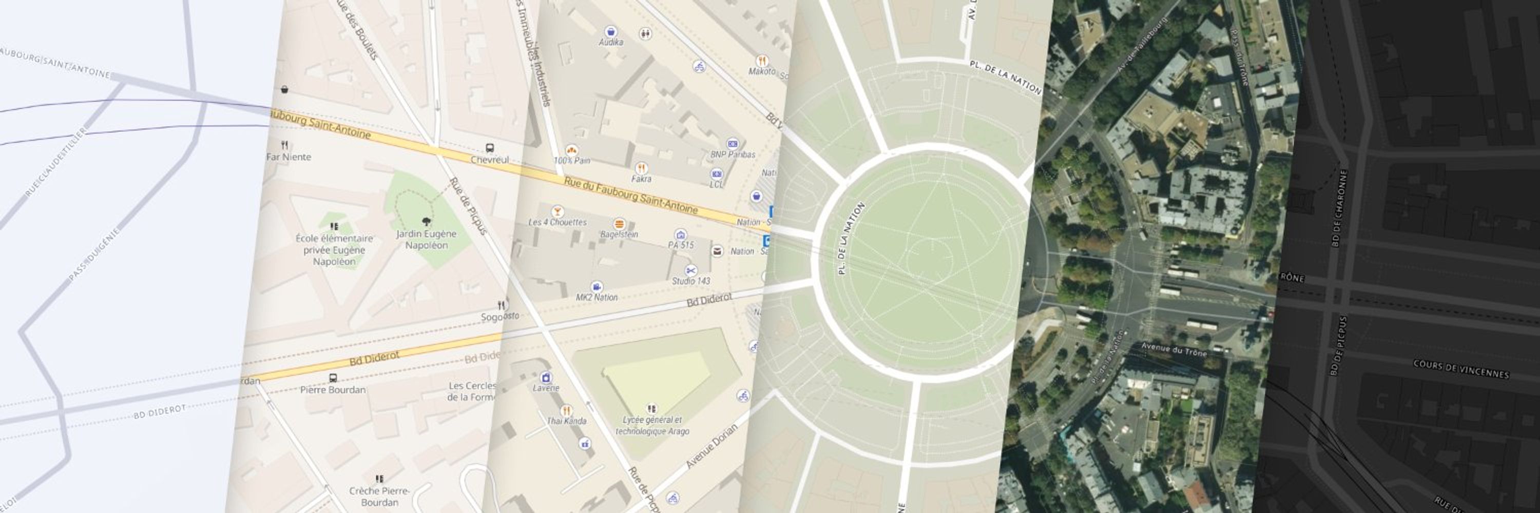
MapTiler
Maps 🗺️ and software for building digital maps, which you can customize and integrate with websites and mobile apps. Join the revolution in web cartography!
@bartvanbossuyt.bsky.social
Simulaties, 3D-modellen en interactieve kaarten voor aardrijkskunde op https://www.interactiveexplainers.com/animaties.html. Leraar aardrijkskunde, wetenschappen en informaticawetenschappen en in een vorige eeuw apotheker. Digitaal onderzoekend leren.
@maplibre.org
@dmajka.bsky.social
I code econo for a large conservation NGO, mostly working on data, maps, and web apps related to conservation and climate change
@tiffcs.bsky.social
ASD advocate | Small business owner supporting underrepresented populations | Web Designer & Digital Marketer | Sustainability & GIS | Florida Mama | Strength in numbers - Get Involved 💙🏳️🌈♻️👩🏾💻🗺️
@6artvde.bsky.social
Geospatial web developer / solution architect. Biggest hobbies are Zimbabwean stone sculpture, hiking, running and PSV Eindhoven.
@tech-timc.bsky.social
Software/Algorithm Developer, Data Scientist. Interests: remote sensing/geospatial, machine learning/pattern recognition.
@dankarran.bsky.social
Freelance geo & web developer who enjoys photography and maps, based in London https://dankarran.com
@simongis.bsky.social
Tinkering with geospatial tech, mainly Esri. Hobbyist map maker, usually of or around Melbourne.. Love bikes and homelab experiments.
@jsonsingh.com
OSGeo Volunteer | Geospatial Developer | PostGIS | Python | Maplibre https://jsonsingh.com
@geovisual.bsky.social
visualization lecturer, researcher, developer. datavis, geovis, uncertainty vis. professor of media informatics and data visualization at university of applied sciences hamburg.
@skovsgaard.bsky.social
Software Developer. C# and Typescript. Silkeborg IF 🔴⚪️ fan by birth. Disappointed AS Roma fan. Bring Sensi back …
@tylerborchers.com
Operations Director. Previously TIME, VICE News and the Village Voice. Posting about media, technology and the future of work. Learn more: https://tylerborchers.com
@seblammers.bsky.social
Creative Technologist | Data Visualization Designer & Developer | Researcher. Always learning something new. (he/him) https://sebastianlammers.com/
@rudoo.bsky.social
Geographer & developer collaborating with Indigenous communities on mapping and data sovereignty. Also on Mastodon: fosstodon.org/@rudo
@jonhealy1.github.io
Software developer, geospatial, blockchain. Love being a Dad, husband, travelling. Working on stacchain and other open-source tools like SFEOS (stac-fastapi-elasticsearch-opensearch). https://github.com/jonhealy1 https://stacchain.github.io
@gsueur.bsky.social
Geospatial entrepreneur @Geomermaids, Cambridge, MA. Data wrangler and occasional developer. Open source advocate. Helping French companies to operate in the US. Licensed Real Estate agent in Massachusetts.
@bluethunder23.bsky.social
@rambeaux.bsky.social
Software/Data/AI/ML Engineer Gone Solo 🐍 Python ← R ← SAS ← ☕ Java ← 🐘 PHP Banking + fintech → bootstrapped SaaS An end, you ask? When I am finished!
@ella0nearth.bsky.social
Water daughter 🌎🛰️🗺️🌲🌊 (U.S. civil servant talking GIS, remote sensing, Clean Water Act, disaster response, etcetera in this time of… transition. Trying to help. Opinions my own.)
@hugocampos.bsky.social
Senior Software Engineer at the Esri R&D Center in Zurich. Working on the ArcGIS Maps SDK for JavaScript. Typescript, CSS, Web Components, WebGL, GIS. He/Him
@amanfromuncle.bsky.social
Open source geospatial - analysis, development & cartography. Shitposting, Cats and Climbing. Opinions my own.
@colleeniversen.bsky.social
Scientist | #Arctic | #Belowground | #Roots | #ScienceEmbroidery | Opinions my own | She/Her | Editor @newphyt www.colleeniversen.com IG: @colleeniversen
@arcvancouver.bsky.social
he/him/his - local GIS guy. Apparently, "king of the well chosen gif" thx KB! Opinions here are my own, not reflective of my employer! 49.25°N, -123°W
@miskaknapek.bsky.social
Data analyst/scientist making data analysis software, #datavis, #datascience , etc, nature photography, some creativity and hobbyist personal complex medical research . ( Did I miss anything?... well, #mecfs ;) miskaknapek.eu
@hatschito.bsky.social
#Geoinformation, #RemoteSensing, #Maps 🌎🛰️, #IT & Sometimes other stuff / @unipotsdam
@bdgroves.bsky.social
🏠 GIS @ Zillow | Advancing real estate geospatial mapping. 🌍 Enthusiast of spatial sciences and their applications in: #GIS | #Cartography | #Meteorology | #Hydrology | #Ecology | #Nature🔬 Exploring the intersections of geospatial analysis, environment
@lutraconsulting.bsky.social
We are one of the QGIS developers. Learn more about our services: www.lutraconsulting.co.uk
@mapaction.bsky.social
Official MapAction Bluesky Account. MapAction brings the power of professional mapping and geospatial analysis to humanitarian crises and preparedness. UK registered charity operating worldwide. Follows don't equal endorsements.
@stijnvanhoey.be
Software/data engineer at fluves.com - currently working on leak detection using fiber optics and water quality sensor data. Freelance developer/teacher. Volunteer at waterlandvzw. Living in Ghent. Python | xarray | django | svelte
@visualisingdata.com
Independent data visualisation expert: Designer, consultant, trainer, lecturer, author, researcher, speaker, host of ‘Explore Explain’ podcast. 🇬🇧 in 🇮🇪 It’s all here http://visualisingdata.com/
@fil.rezo.net
maps | data | code | journalism #D3 & #Observable 👁️🗨️ https://observablehq.com/@fil 🌍 https://visionscarto.net/
@thomasg77.bsky.social
Freelance SIG libres, OSM & OpenData /w JS & Python. Auteur livre OpenLayers. Pro Webgeodatavore + http://formation-openlayers.fr Coopère ouvre-boites
@andrea-mcm.bsky.social
🛰️🗺️ Satellites and maps | Dpty. Director of Environmental Mapping at https://sig-gis.com/ | She/her | 🇩🇪 in 🇺🇸 | born at 351 ppm
@uk.osgeo.org
@ausp.io
Father, Open Geospatial Technologist, Digital Earth Architect. Auspatious: https://ausp.io
@cartonaut.bsky.social
@cartonaut elswhere Map-o-phile / GIS wrangler / M.S. GIS / GISP / mischief / 🗺️ / solvitur ambulando
@mastermaps.com
GIS lead for DHIS2 Climate & Health (dhis2.org/climate) and Norwegian Trekking Association (UT.no). MSc with distinction in Geographical Information Science. Open source and open data advocate. Environmentalist. Orophile. 🏳️🌈
@geospatialwomen.bsky.social
A global network that inspires, unites and empowers women+ in the geospatial field to become strong changemakers.