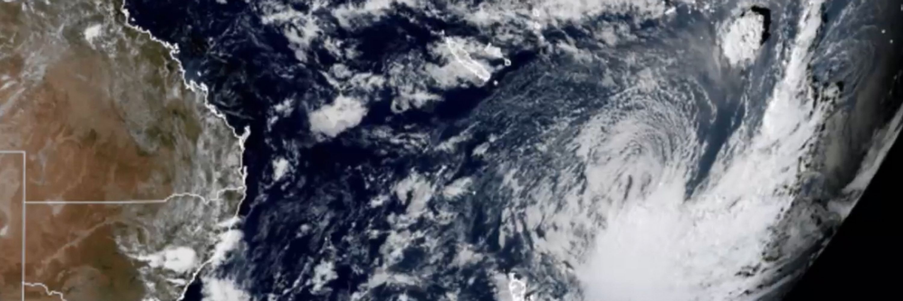
James Holbeach🌀
A fluid mechanist engineer specialising in multiphase flows with a passion for science, motorsport, satellite imagery, astro / space and weather, in particular Cyclones, typhoons, hurricanes! Based in Western Australia but travel the world!
@earthfromspce.bsky.social
Sharing satellite images & astronaut photos of our incredible planet and explaining the amazing science behind them! 🛰️📸
@mauri-pelto.bsky.social
Glaciologist who has spent 40+ years doing fieldwork on glaciers. Science advisor to NASA Earth. US Representative to the World Glacier Monitoring Service. Author of blog “From a Glaciers Perspective”. Grandparent, avid skier, dog walk/runner.
@ywyue.bsky.social
ELLIS PhD student at ETH & Oxford. Ex-intern at Meta. 3D Vision, Machine Learning, Photogrammetry. ywyue.github.io
@cloudnativegeo.org
Where geospatial data users create the future together. Join - cloudnativegeo.org/join
@sebrobertson.bsky.social
Husband. Dad to 3 epic kids. CEO & Co-Founder of Birdi (a geospatial platform). President of Earth Observation Australia (EOA). Founder of Batyr (preventative youth mental health). Lover of all things sport, emerging technologies, businesses and economics.
@pieschker.bsky.social
geographer, librarian, formerly landsat, now water mission area focused, metadata, information storage and retrieval, information seeking behavior, science support,
@kristi-liu.bsky.social
Remote Sensing, GIS, Biodiversity data: GloBi, GBIF, iNaturalist, TDWG/SPNHC 地理学・生物多様性情報データ ・理科甲子園 UCSB Library and Cheadle Center
@ahmadalbitar.bsky.social
Scientist | Engineer | Earth Observation 🌍 | Hydrology 💧 | Carbon 🌿 https://www.cesbio.cnrs.fr/author/ahmad-al-bitar/
@environmondal.bsky.social
Associate Professor of Environmental Geography; EASEL lab PI (easel-lab-mondal.com); Associate Director, MS Data Sc.; Editor, AMS Earth Interactions; Geospatial Data Scientist; Remote Sensing and GIS enthusiast; Geo(=earth)-lover: Geo(logy)-Geo(graphy)
@yassermaghsoudi.bsky.social
Senior Lecturer in Radar Remote sensing at University of Exeter, Department of Earth and Environmental Sciences. #InSAR #Geohazards #Remote_sensing
@srapach.bsky.social
Spending most of my time looking at Earth from Space | Research focuses on Earth Observation technology, human rights, socioeconomic research, scientific evidence | University of Strathclyde | (She/her)
@geoskeptic.bsky.social
Matthew is just this guy, you know? Remote sensing, open-source and geospatial @element84
@amanbagrecha.bsky.social
Co-founder Let's Talk Spatial. All things remote sensing and AI. Amanbagrecha.github.io
@ustuner.bsky.social
Assistant Professor at Samsun University 🇹🇷 working on machine learning for SAR & Hyperspectral #RemoteSensing Data Analysis Website: https://mustuner.github.io/ Google Scholar: https://scholar.google.com.tr/citations?user=KtXqoWkAAAAJ&hl=en
@chinyereottah.bsky.social
PhD Candidate @McMasterU | Research interests: Wildfire, #ClimateChange, Carbon Emissions, Forests, Peatlands, Lidar, and Remote Sensing.
@padster.bsky.social
Earth Observation Leader | Geospatial Intelligence | Ex-Descartes Labs | Commercial Director @ EarthDaily | MBA This year we are launching the world's first constellation to image the entire Earth daily across 22 spectral bands 🇮🇪 → 🇬🇧 → 🇦🇺
@catherinefrock.bsky.social
Wildlife ecologist | Conservation biologist #conservation #movementecology #animalpersonality #scicomm #AltAc #PostAc
@jepsonnomad.bsky.social
Spatial ecology, seasonality, climate change, migration, and remote sensing. From snow, plants, and ungulates, to rain, humans, and coral reefs. Postdoc in the ‘Pile at UCSB. https://scholar.google.com/citations?hl=en&user=VPd60tMAAAAJ&view_op=list_works
@uclgeomatics.bsky.social
The UCL Geomatics Section is involved in the science, engineering and modelling of measurements and data relating to Earth and its environment. https://www.ucl.ac.uk/civil-environmental-geomatic-engineering/research/groups-centres-and-sections/geomatics
@shirzaei.bsky.social
Professor at Virginia Tech, Lead, Land Subsidence Analytics at United Nations University, US Rep. to UNESCO LASII Web: EOIvt.com
@jakubnowosad.com
Computational geographer. Associate Professor at AMU, Poznan, Poland. Co-author of http://r.geocompx.org, http://py.geocompx.org, and http://r-tmap.github.io books. #rstats #rspatial #geocompx https://jakubnowosad.com/
@frediotto.bsky.social
🇬🇧 🇪🇺 physicist, philosopher, lead https://www.worldweatherattribution.org/, author of Climate InJustice https://greystonebooks.com/collections/current-affairs-politics/products/climate-injustice, she/her
@rahmstorf.bsky.social
Climate scientist, professor of Physics of the Oceans in Potsdam. Opinions my own.
@aprados1.bsky.social
Scientist @UMBC working at the intersection of #disasters #risk #wildfires #airquality and #remotesensing
@hakimabdi.com
Research scientist in geospatial ecology | Ecosystem Remote Sensing🛰️🌍 | Forests, Savannas, and Drylands | Birds and Birding in the far south of Sweden 🐦🇸🇪 | الحمد لله | Own opinions, usual caveats. https://www.cec.lu.se/hakim-abdi
@flaviamendes.bsky.social
Remote Sensing expert @planetlabs #forest🌳 #LUC #carbon #supplychain | Geospatial Rising Star 2022 | @GoogleDeveloperExpert #EarthEngine, co-founder of geoinclusion and member of @rsategroup #earthobservation #Amazon #Cerrado
@miguelmahecha.bsky.social
Earth system data sciences Prof. @UniLeipzig @RSC4Earth related to @UFZ_de @iDiv @SCADS.AI, worried about climate extremes, biodiversity, the human-environment nexus and the 🌎's future in general. Editor @EnvDataScience
@bevanda.bsky.social
Biologist, earth observer, UAS/UAV/drones for ecology @eor-wuerzburg.bsky.social
@schwalb-willmann.de
Spatial Data Science, Earth Observation, Machine Learning 🌍🛰️⚙️ Animal-Environment Interactions Modelling, Sat./UAV Remote Sensing for Ecology. Researcher & Lecturer @earth-observation.org, @uni-wuerzburg.de, #AniMove. https://jakob.schwalb-willmann.de
@matthiasforkel.bsky.social
Environmental remote sensing: microwaves and data-model fusion for vegetation, fires, water, carbon cycle, Prof @TUD Dresden University of Technology
@tanyashapiro.bsky.social
Warning: Posts May Contain Graphic Content 📊 • Data Viz • Freelance for Hire • She/Her 🏳️🌈 https://indievisual.tech
@jcsvenning.bsky.social
Scientist: #biodiversity, #macroecology, #climatechange, #restoration & #rewilding, #novelecosystems, #plants & #vegetation, #megafauna, #human-#nature relations & #remotesensing. Director, https://econovo.au.dk/
@sarndt.bsky.social
Sea ice physicist at AWI with research focus on Antarctic sea ice and snow. Emmy-Noether Young Investigator Group leader. Lecturer at University of Hamburg. Junior fellow at HWK. Science communicator.
@sabrinaszeto.com
🛰️🗺️👩🏻💻co-founder @thrivegeo.bsky.social & @geospatialwomen.bsky.social | 📚 closing the skills gap in #geospatial data literacy | #EarthEngine GDE | #earthobservation #EdTech #upskilling
@underdarkGIS.fosstodon.org.ap.brid.gy
#SpatialDataScience | #MovementDataAnalysis | #OpenSource #Geospatial | @qgis PSC Member | Creator of @movingpandas & #Trajectools | Senior Scientist & […] [bridged from https://fosstodon.org/@underdarkGIS on the fediverse by https://fed.brid.gy/ ]
@halabisky.bsky.social
Remote sensing ecologist. University of Washington Research Scientist and Senior science advisor for Digital Earth Africa. Background in conservation management and wetland ecology.
@earthbytelab.bsky.social
earthbytelab.com #geospatial #remotesensing #earthobservation #datascience #earthengine
@satellitesci.bsky.social
Coastal Earth Observation Scientist from Canberra, Australia. Using satellite remote sensing 🛰️, open-source geospatial 🔓🗺️, Python + R 🧑💻 and dataviz 🎨 to map the earth through space + time... 🌏
@joemorrison.bsky.social
“Controversial industry figure” - Grid News. VP of Commercial Experience at Umbra Space. 🛰 | satellite data for mapping 🗺, monitoring 📈, and 'mergencies 🚨
@morganahcrowley.bsky.social
Forest Fire Research Scientist with Canadian Forest Service 🔥🌲🌳 and the WildFireSat mission 🚀🛰 📡 | Advancing how we use satellites to monitor fires and their impacts | Woman in Remote Sensing | Mother in Science 💻👩💻👩🔬🧪 | she/hers | celiac | 📚🎵🎶👟☕️ | 🇨🇦🇺🇸
@copernicusecmwf.bsky.social
The #CopernicusClimate Change Service (#C3S) & #CopernicusAtmosphere Monitoring Service (CAMS), implemented by @ecmwf.int on behalf of the European Commission.
@rsimmon.bsky.social
Data Visualization. Ex-Planet & NASA Earth Observatory. Blue Marble, Earth at Night, color, cartography, occasionally skewed views of Earth. Looking for a job.
@giswqs.bsky.social
Associate Professor @UTKnoxville | Amazon Scholar | Creator of #geemap & #leafmap | Talk about #Geospatial #GeoPython #DataViz #GIS #FOSS #EarthEngine
@micheletobias.bsky.social
California Beach Biogeography & Geomorphology, Geospatial Data Science, Cartography, Open Source, Library Employee, and definitely some cats. OSGeo - FOSS4G - #gischat - #maptimeDavis